FIELD NOTES (LOG NOT BLOG)
Early ‘80s Vortex
Los Angeles. June 24, 2023
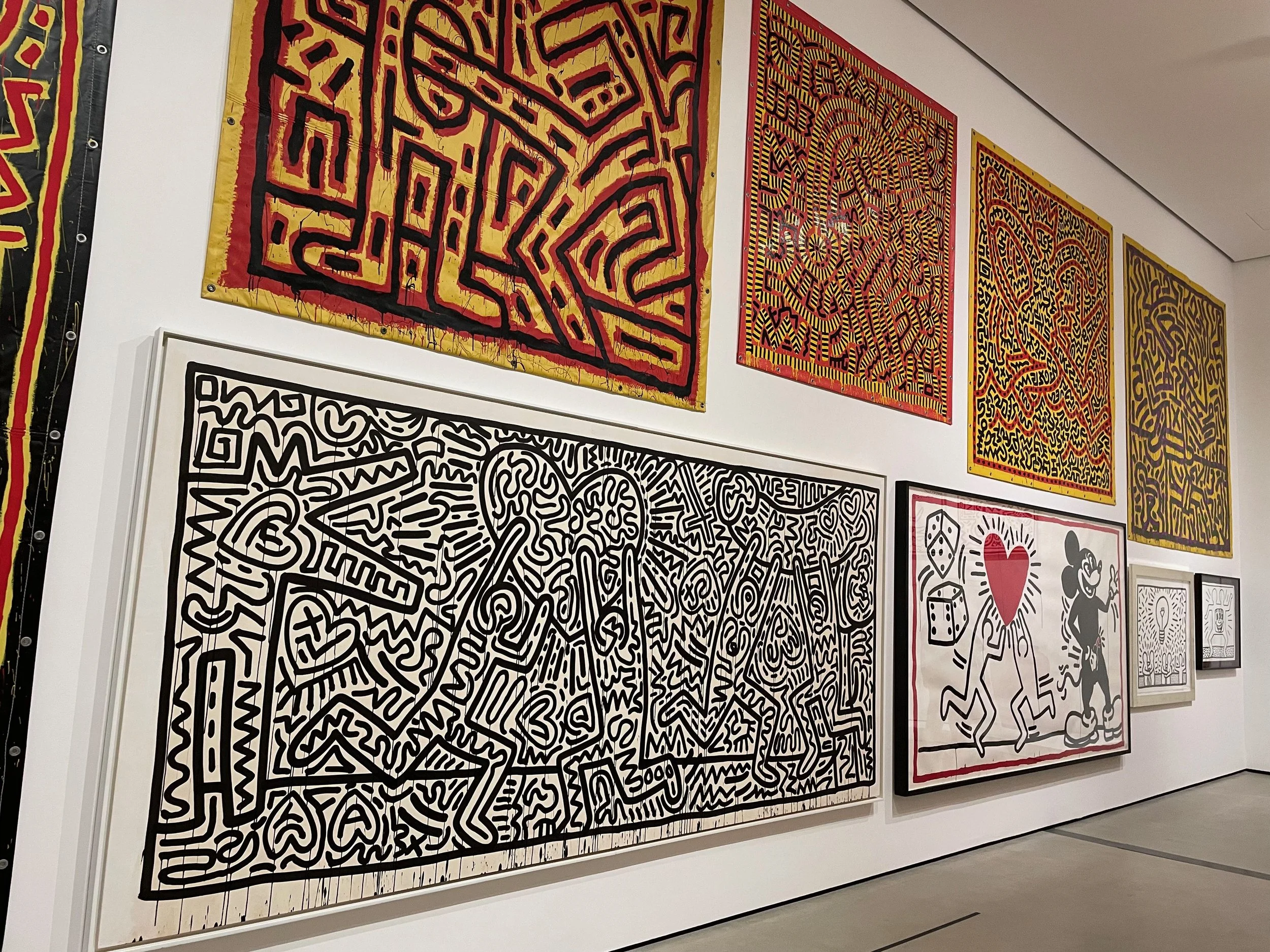
Two days ago I stepped into a full early 1980s time warp. That afternoon I went to a major retrospective of Keith Haring at the Broad Museum in Downtown Los Angeles. It’s a big show: 120 works and objects spread across ten rooms, spanning his prolific but short career—he died of AIDS in 1990 at the age of 31. When I lived in NYC during the second half of the 80s Haring was in full effect— his art was everywhere: on walls, posters, T-shirts, in dance clubs, on buses. New York City was covered in Keith Haring. I thought I knew what it was about. But this show widened my frame. His early work isn’t just cheerfully cartoonish but unabashedly pornographic—there are phalluses and anal sex everywhere in the Broad galleries, and his late work was more sophisticated and nuanced than I knew. All reminded me of the intensity, energy, and cross-pollination of the NYC scene in those years. Haring was a committed collaborator, working with people across the range of his communities, which all overlapped: gay, graffiti, hip-hop, downtown club scene, political activism. He was relentlessly political, in his art and private life, deeply involved in the high-stakes struggles of the Reagan Era—the AIDS crisis, nuclear disarmament, the fight against apartheid in South Africa and police repression at home. It’s the first LA show of Haring, which seems scandalous. But note that LA has a long and deep graffiti tradition, and none of those artists have had a big show in our establishment institutions, either.
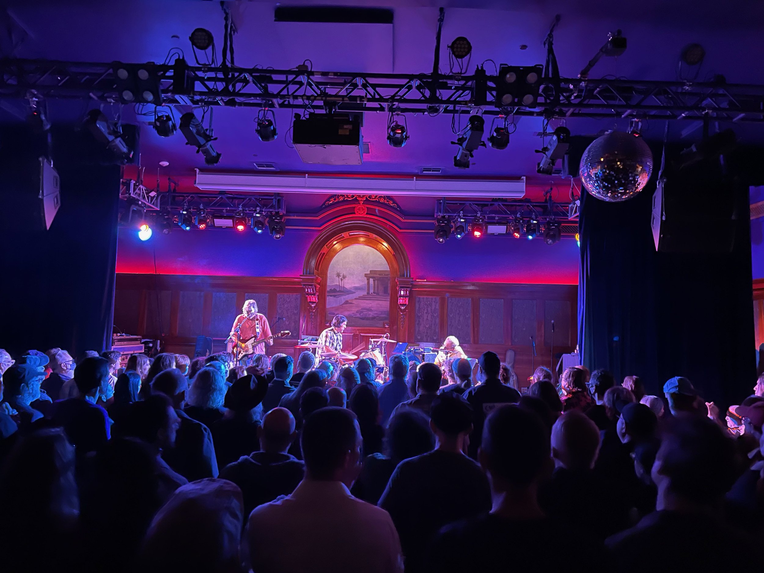
In the evening I went to the Lodge Room in Highland Park to see (versions of) two of the most seminal punk bands of the late 70s and early 80s: Pere Ubu from Cleveland, Ohio and the Minutemen from LA’s San Pedro neighborhood. The Pere Ubu band, with the MC5’s Wayne Kramer on guitar, and sadly, David Thomas confined to a wheelchair but onstage nevertheless, ably brought forth its signature punk art noise. For me anyway, the opener was where the heat was: Mike Watt and the Missingmen, the current three-piece incarnation of Watt’s tireless, lifelong performance project. They cranked out Minutemen and later songs: insanely tight, syncopated, weird, sui generis punk-thrash-jazz-funk. That’s a weak way to describe it, because the music is pretty much indescribable. Both bands reminded of how, at the raw edges of the punk movement, untethered young artists opened up totally new spaces, filling them with new sounds and shapes and tightly-wound street soul. Of all the punk bands, the Minutemen were maybe the fiercest and funniest anti-Reaganite resistance fighters. (The Clash had no evident sense of humor—or I missed it.)
We could use more of that 80s spirit now.
ways to make a living
A man, a mule, and a dog, tracing the wild at Mineral King. August, 2020.
In Japanese, yomikata means way of reading. It can apply to almost anything that might be read: kanji characters, sign language, people’s faces, or clouds for signs of impending weather. We don’t have such a word in English, but we could use one.
Some years ago I was camping at Mineral King, the spectacular, glacier-carved valley on the western slope of the Sierra Nevada in California, part of Sequoia National Park. The valley is perched above 7,000 feet, draining the high peaks of the Great Western Divide, a craggy, granite range of peaks, some 11,000 feet high, into the East Fork Kaweah River to the west. Separated from the main portion of the park by the river canyon, Mineral King is reached by a 25-mile, torturously windy road, has no commercial services, and so is relatively lightly visited. I was there on the 30th of October, one day before the campground, 40 sites threaded through the forest on the banks of the river, would be closed for the winter. There was only one other vehicle in the campground, and in the evening I walked past it. A man was there, with a dog, a German shorthaired pointer, close by his side. A mule stood inside an enclosed metal stall that had been custom-built onto the back of the man’s pickup truck—a horse trailer without the trailer. After nodded hellos, I asked him about his unusual companions and rig. What he told me was an extraordinary description of a unique job and the skillset needed to do it.
In a drawl that struck me as being just like some I’ve heard in Utah—Great Basin cow country accents—he explained his errand. He was from Bishop, California, the seat of Inyo County, at head of the Owens Valley, the eastern Sierra basin sandwiched between the 14,000-foot high peaks of the Sierra, topped by Mt. Whitney, and the 14,000-foot high White Mountains—the valley from which the city of Los Angeles infamously stole the water of the Owens River in the early 20th century. The Owens Valley is geophysically in the Great Basin, and shares its hay-and-cattle economy and culture, which accounted, I imagined, for the accent. It sits almost exactly due east of where we stood, thirty miles as the crow flies, but a 300-mile trip by road around the bottom end of the roadless southern Sierra. He had been hired as a tracker by the state Department of Fish and Game to perform a predator survey in the high country around the Great Western Divide, in advance of a project to relocate bighorn sheep from the eastern part of the Sierra to the western part, from which they had been extirpated, at least in part by diseases passed to them by domestic sheep pastured in the mountains. This disappearance was part of a catastrophic decline of the animals, once widespread in the range, in the face of disease, hunting, and finally, increased mountain lion predation in the 1980s, until by 1995 just 125 adult bighorn remained in the Sierra Nevada. Efforts at translocating bighorn from the two remaining surviving herds around Mt. Whitney to other former habitats were stymied first by mountain lions, whose numbers were rising after California banned their sport hunting, and second by the sheep then choosing to evade the cats by remaining at high elevation in the winter, and so succumbing in large numbers to extreme cold, snow, and avalanches. When specific lions were removed from translocation areas, sheep numbers improved.
In this case, members of a recovering herd in the Mt. Whitney area would be tranquilized and flown by helicopter in suspended nets across the Kern River plateau which stretches between the eastern and western peaks—a wooded expanse they could not cross on their own in the face of predation by mountain lions. The man’s job was to determine the number and location of mountain lions in the relocation area, in order to quantify the threat to the sheep. If warranted, some of the lions would need to be killed before the project went forward. Each morning before dawn, he told me, he and the mule and the dog set out for the high country, looking for signs of the cats. I asked him how, since most of the bighorn habitat was above treeline where there was little vegetation or even soil, he could discern signs of their presence. In his steady drawl, he said there were plenty of signs if one knew how to read them. The pointer, to begin with, would point when its nose picked up a cat’s scent, guiding the man and mule along the precise pathway the animal had followed. Scratch marks, rubbed trees and rocks, tufts of fur left on twigs, kills, and scat fleshed out the story, giving clues to the lions’ ages, diets, movements, patterns, health, and even family life. The high Sierra, a severe landscape of rock and ice and flattened, stunted conifers, was to him an open book from which he could read the saga of the mountain lions’ existence, and predict the likely interactions that would take place with the bighorn when they returned to the country. Furthermore, he was multilingual, able to understand the languages of mountain lions, German shorthaired pointers, mules, and bighorn sheep, to begin with. Each trace or voice is a strand in the the collective story of the ecology of the place, an almost unimaginably complex web of relationships between creatures, plants, geology, and the elements. And he could not only read it—the yomikata of the mountains—but translate it into English, in several dialects: the vernacular that he spoke to me by a mountain campfire, and the biological and procedural jargon that he would use to write his formal report to the state agency to help guide its decisions.
I was amazed, impressed, and grateful that such people with such skills exist. But I also knew that the ability to read the land is available to anyone who wants to try to learn it. The information isn’t classified, it’s right there for us to engage with. All we have to do is go outside, and pay attention. I wished him luck the next day, bade good night, turned towards my own campsite, and zipped up my jacket against the descending cold of the Sierra in late October.
* * *
After an emergency listing of the Sierra Nevada bighorn under the state and federal Endangered Species Acts in 1999, the state put into motion a systematic program of translocation, coupled with selective removal of mountain lions—averaging about one per year since 2000. Radio-collaring the lions and close tracking on the ground provided the targeted information in those decisions. The population of bighorn rebounded dramatically, and today there are more than 1,000 Sierra Nevada bighorn sheep in the mountains of California.
Recovery Plan for the Sierra Nevada Bighorn Sheep, US Fish and Wildlife Service, 2007:
https://nrm.dfg.ca.gov/FileHandler.ashx?DocumentID=27634&inline
lomi oʻio
A Molokai fish story. Papohaku, Kaluakoʻi, Molokai, Hawaii. July, 2019.

Oʻio, bonefish, Albula vulpes.
On the sand below, scalloped lines join together to weave a fabric of endless, miniature dunes. With each pulse of the waves, a tiny rooster tail of sand is blown off the peak of each ridge, then settles into the scoop of its valley; each return pulse blows an opposite rooster tail back. Back and forth, each linked line of scallops draws a scaled-down, sandy echo of the waves passing above. The bright, translucent green water dimmed in an eyeblink from to ashy shadow as the sun dipped below the horizon. I’d met Uncle B. just before sunset, wearing swim trunks, as agreed, to help him set the net. He’d motioned me to help him pull the mound of gill net out of his pickup bed, then follow, carrying half of it, across wide Papohaku Beach to the water’s edge, where we stretched the net out along the sand berm. He tied a 25-pound dumbbell weight to the bottom rope on each end. We pulled on fins and masks and walked into the water, him cradling the weight and me guiding the net behind. We pushed through the waist-high waves and began to swim, slowly and methodically, straight out from shore.
In August, here on the West end of Molokai, the water is generally calm, and setting a net off the beach overnight is a comparatively simple matter. In winter, this same beach is almost daily pounded by the huge swells that track from Alaskan storms toward the north-facing coastlines of the Hawaiian Islands, and swimmers enter the water at considerable risk.
As we swam, the bottom gradually receded from view, and the sand scallops, so intricate close to shore, became larger and dimmer until they disappeared completely. At about 200 feet from shore, Uncle B. swam down, in 20 feet of water, and dropped the weight on the sand, where it would anchor the long net, which stretched back to the berm, held on the surface by floats, trailing a 7-foot curtain of 2 3/4-inch square gill net.
We swam back to the beach, each picked up another weight, carried it into the surf, and began to swim out again, along the line of the net. Every 20 or 25 feet, we swam down to the bottom, dropped the weight on the sand, and tied it to a trailing line, to hold the mesh curtain vertical and taut against the pull of the floats. The water was now so dark I could barely see the bottom. I worked as fast as I could, my mind-screen filled with images of sharks lunging out of the murk—hammerheads, like the one Uncle B said he’d once found tangled in his net one morning, dead.
It was dark when we finished the set. We would meet in the morning, before dawn, ready to swim out and see what the night brought. During the summer, a gentle current sweeps southbound along Papohaku’s 2-mile length, and fish, nowhere to be seen during the bright daylight hours, where there is no cover for them over the sandy bottom, come close to shore during the night, swimming against the current in search of food. Any too big to slip through the mesh would be caught. Our job was to harvest them before the next day’s sun could find them and accelerate the process of decomposition. The night acted as a kind of refrigerator.
Uncle B. lived up the hill, in Maunaloa town, formerly the HQ company town of a California-owned pineapple company, now much diminished in size and prosperity, but still home to a small, tight-knit community, many of them, like him, of mixed Native Hawaiian and Filipino origins. He had agreed to show me, a haole new to the island, how to set a lay net off the beach in the traditional way. As the sun began to light the outline of the Maunaloa ridge to the east, we pulled on our fins, walked in, and began swimming straight out in the calm water. I saw the first fish motionless in the net—one, several, then many. Uncle B. swam down to the first and carefully disengaged it with a backward motion to free its spines from the netting. Wrong kind, though I can’t remember what name he used, and he let it swim free. We swam to the end of the net, then down to the bottom to untie the weights, one by one, back toward the beach, until the net floated free. On the beach, we dropped our gear, and began to pull the net in. From a nearby house came M., the Native Hawaiian caretaker of a property owned by a California family, paid for with proceeds from the Orange County mortgage business. He kicked off his sandals and silently lent his hand to the pulling.
As the net came in, silver fish held at odd angles bounced along the sand. Most were lai, or leatherbacks, a little under to a little over a foot long, longish and slender, bright silver with a bluish top, and smooth, oddly-scale-less skin. B. and M. grabbed each one carefully, and explained to me how to push backwards on the fish to free its splayed fins from the net strings without being pricked by its spines. I got pricked, badly, more than once, and felt the fish’s poison immediately burn, even before the spot of blood formed on the skin and ran.
“The venom apparatus of Scomberoides sanctipetri consists of seven dorsal spines, two anal spines, their associated musculature, venom glands, and integumentary sheaths. The anal stings, in contradistinction to most other fishes, are the most highly developed of the fin stings. The anal stings are controlled by a frictional locking device. The venom glands of both the dorsal and anal stings consist of large glandular cells measuring 7–10 by 15–20 μ in diameter, which are confined largely to the basal and middle layers of the epithelium.”
We put the lai, dozens and dozens of them, and a welter of other, smaller silver fish into plastic buckets, then emptied them into the bed of Uncle B’s pickup. M. would take some home for his part in the harvest, B. some more, and then hand out the rest to various “aunties” up in Maunaloa town who were in Uncle B’s church group and who held the fish in high esteem. Lai or its close relatives are widespread in the tropical Pacific, including the Philippines, where many of those aunties had roots, and where they are one of several prized fishes called lamarang—also including mahi mahi.
I’d never heard of them. In Hawaii, they are neither well known nor especially prized, except by flyfishermen, who are scarce here, but who appreciate the fact that it is one of the only Hawaiian fish to jump after taking a hook. “It travels in small schools and comes into bays and harbors freely. It feeds on small schools of mullet and nehu (Hawaiian anchovy). As a table fish, the lai is average in taste. Once the meat is filleted, it makes for fine sashimi. Breaded on floured and deep fried it makes for a great fish sandwich or a great main course.”
There were also four larger fish, between 14 and 20 inches long, that had been caught towards the end of the net. They were striped, with big fins and cat-like faces, and a square-sectioned body somewhat like a bigger, longer boxfish. These were oʻio, bonefish, Albula vulpes, beloved by fly casters throughout the subtropics for their willingness to take a fly and to fight gamely, but reviled by cooks for their numerous, sharp bones and crumbly, un-filletable flesh. Most anglers throw them back. Those determined to eat them grub out what meat they can, pick out the gazillion tiny bones, and make fishcakes to fry.
But in Hawaii, there is a better way. A couple of years before, at an afternoon potluck party, one of Molokai’s most experienced fishers had shared some with me, and told me how make it. Aunt J. was diminutive—barely five feet tall—slight, garrulous, and a hardcore Native Hawaiian fishing kumu. She knew where to find octopus on the reef flats, big ulua on rocky shorelines, and oʻio in shallow, sandy bays. She had handed me a tupperware filled with a jello-like, nearly translucent paté and gestured for me to take a cracker and scoop some up. It was cold, delicious, and melted in my mouth. This was bonefish? I asked. She smiled.
Lomi oʻio. Lomi meaning to squeeze with the hands, like lomi lomi traditional Hawaiian massage. Only, to the fish. No fillet, no cook. No gut, even. Just take the fish, she mimed, and make two cuts on top, one either side of the spine. Run the knife down the bone combs and scrape away the meat. Use a spoon to get all of it, scooping out like ice cream from a bucket. Put it in a bowl with some ice cubes to make the meat gel into little clumps, easier to work with and separate from any bones. Make two cuts along the bottom, again both sides, and scoop away. You could also use a beer bottle to roll the flesh out, like squeezing a tube of toothpaste. Throw away the carcass. Put your hands in the bowl and lomi, taking out any scales or pieces of bones as you feel them. Add a little limu kohu seaweed and some roasted kukui nut, just like you would for poke, and salt. Refrigerate for a while. That’s it.
I took two of our netted oʻio and a few lai. Uncle B. drove the rest up the hill to Maunaloa and his aunties. I remembered what Aunt J showed me, and it worked, beautifully. Local knowledge. Molokai manaʻo.
FOOTPRINTS
In the Antelope Valley, L.A. County, California. April 30, 2019.

You can see it glowing red-gold from 30 miles away, an improbable gold mountain in the middle of the desert. In March and early April, the wildflowers blooming in the Antelope Valley California Poppy Reserve in the Mojave Desert west of Lancaster are so bright they can be seen from space: the fire-ember orange of the poppies, yellow goldfields, purple lupines and phacelias, and pale butter-yellow tidy-tips, mixed in swirls and splotches like a landscape-scale abstract expressionist painting.
They can also can be seen from cyberspace—indeed it’s almost impossible not to: the “superbloom” of wildflowers all over California has been a global phenomenon on social media: just check #superbloom or #californiapoppies for their hundreds of thousands of posts. There are eye-popping shots posted from Anza-Borrego Desert State Park, and psychedelic Walker Canyon near Lake Elsinore, but the superbloom’s crown jewel is here, in the low, rounded hills at the western edge of the vast Mojave.
Up closer, the reserve looks like a scene from The Wizard of Oz, but these poppies are real, a seemingly endless carpet woven of innumerable flowers waving in the incessant wind. Distant mountains—Mt Pinos to the west, the Tehachapis and Southern Sierras to the north, and the San Gabriels, still rapturously snow-capped, guarding the Los Angeles Basin to the south—show the huge scale and diversity but also the essential connectedness of California’s ecosystems.
Among the fields of flowers is another, remarkable profusion: people. Slow, snaking lines walk along the trails, gawking and posing for pictures—many wearing costumes of big sunglasses, hats, and billowy dresses expressly designed for their Instagram moment. But others walk off the trails into the fields, in spite of ubiquitous signs reminding them not to, stepping on the flowers, picking them, often laying down in them, to get their smiling faces right up close to the petals for that perfect selfie. One enterprising couple even landed their helicopter in the middle of a poppy field to get theirs.
For these delicate plants, trampling kills the first time—just one footprint does the job. And one footprint encourages others: everywhere there are trod paths, squashed areas, and dead, dry, compacted dirt.
As the superbloom peak has moved from place to place, following rainfall and warming spring temperatures, obsessively documented on social and other media, so too have the horrendous traffic jams and selfish behavior in pursuit of selfies, leaving once-pristine landscapes trampled and scarred.
In response, there has been much hand-wringing and online outrage. Overwhelmed by traffic, Lake Elsinore authorities even shut Walker Canyon, briefly. But the superbloom, and the frenzy, continued.
Why would so many people feel no compunction in destroying the thing they came so far to celebrate?
From the hilltop vantage of the poppy reserve, it’s not hard to see that trampling, on a vast scale, is our standard modus operandi in California. The 1,781-acre reserve is just a tiny remnant of a high desert grassland ecosystem that covered hundreds of square miles. Once, the Antelope Valley was home to tens of thousands of antelopes—pronghorns actually, but they died of starvation en masse when the railroad came in 1876 and blocked their way to seasonal food supplies; the rest were killed off by settlers.
Since then, the Mojave Desert landscape has been ruinously and massively scarred: by mining, the military, and farmers, who plowed up 45,000 acres of thin desert soil to grow crops watered by fossil groundwater. As the aquifers were sucked dry, 35,000 acres have been fallowed or abandoned, and the topsoil blown away by the Valley’s fierce winds, also unleashing Valley Fever, a fungal disease caused by naturally-occurring Coccidioidomycosis spores, or “cocci” from the soil, a respiratory disease that can be fatal and is nine times more common in the Antelope Valley than in the rest of LA County.
Power lines and fences string out in all directions, as do roads, some paved, most not, carved into the desert to form a massive grid sprawling over 200 square miles between Lancaster and its neighbor Palmdale. The gigantic grid is the record of an optimistic greed, in hopes that this desert would soon be developed, like the rest of Southern California’s 10,000 square miles of sprawl stretching from the Mexican border to Ventura. Once a sleepy rural outpost, the valley began to boom in the 1980s, fueled by Reagan-era military spending and cheap tract housing that attracted 70,000 daily commuters to LA. Chronic busts have followed, from the end of Cold War defense downsizing to the housing crash of 2008, yet still the population grew 8-fold, from 60,000 in 1980 to nearly 500,000 now. And yet the Antelope Valley’s bulldozed road grid remains mostly empty, studded with absurd, desolate intersections such as 300th Street West and Avenue A, 30 miles from downtown Lancaster.
The cost to the desert’s delicate ecosystems has been steep: not only are the pronghorn gone and square miles of Joshua Trees bulldozed, but desert tortoises and other animals struggle to survive on shrinking fragments of habitat, hemmed in on all sides by our ever-sprawling footprint.
The drive out to the reserve along Avenue I from the 14 freeway is a dispiriting tour of things we have tried to put out of sight and out of mind, each placed on cheap desert land in an effort to solve one immediate, pressing problem, then another. Miles of dusty, low-rise tract homes give way to fallowed, weedy fields here and there dotted by walled, treeless housing developments (the high desert is increasingly home to Section 8 voucher holders unable to find housing elsewhere in the Southern California), a state men’s prison, a juvenile hall, an animal shelter.
In the distance, the orange fields of poppies beckon, mixed in with patches of yellow goldfields and darker ones which appear to be lupines. But on closer inspection the dark patches are not flowers at all, but commercial solar farms, arrays of photovoltaic panels spread across the desert floor for many miles, together constituting the largest collection of solar arrays in the world. A single one, sprawling over 3,200 acres, is the largest solar farm on earth. (Yes, they can be seen from space.)
Ironically, this “green” energy infrastructure was bulldozed on top of the real green on the ground. The farms were cited here for “good” reasons: many on already-degraded former farmlands, and close to existing transmission lines to the L.A. megalopolis. They have helped California to meet 50% of its energy demand with solar on a sunny day. But the same area of panels could have been mounted on existing urban rooftops, especially the huge warehouses that have proliferated in recent years as more and more of our goods come from overseas.
A recent state law mandates solar panels on all new construction beginning in 2020—a welcome and overdue step. Solar capacity is expected to actually exceed maximum (springtime peaking) demand by 2022. But no amount of daytime solar power can wean us completely from fossil fuels without major investments in efficiency, energy storage, and distributed generation, and these ought to be sited as closely as possible within the existing urban footprint.
The nature of environmental problems is complexity and interconnectedness. As John Muir said: “When one tugs at a single thing in nature, he finds it attached to the rest of the world.” Too often, we make policy decisions in fragmented silos, each piece of a problem handled by a separate agency, authority, or jurisdiction, without coordination with others.
Unfortunately, no amount of renewable energy of all kinds will solve the planet’s ecological crisis, which includes climate change but also extinction, the collapse of food webs, plastic pollution, and on and on. We must begin considering our footprint as a whole and seeking to reduce it, everywhere, by stacking policy goals together, rather than attacking them separately.
In California, our policy is still to encourage sprawl: the continued growth of desert solar farms as well as the L.A. County Board of Supervisors’ approval last December of the Centennial development, 19,000 homes to be built on pristine lands 70 miles from downtown L.A., attest to this.
In the poppy fields, there is reason for optimism: not far from the reserve, eruptions of orange in an old, fallowed alfalfa field show that the land, even badly scarred, can heal itself, if we let it.

Fueling
Moab, Utah. July 2, 2016
At a gas station in Moab, a Thursday afternoon in June, the temperature a little over 100, heat rising from the oily asphalt. The pumps are lined with vehicles gassing up: 4 x 4 pickups, lots of Jeeps, old, local and dented, and new, jacked up, stud-tired, and rented, offroad Tonka toys for the slickrock trade; also little nondescript rental sedans packed with tourists, mostly apparently Chinese couples in shapeless cotton clothes in primary colors, and clutches of Euro dudes sporting horizontally striped shirts, spiky, dyed haircuts, and sunburns. They’re headed for the national parks, the Indian ruins, the river, the redrock desert, what they don’t have at home. What they have in Utah. Inside, I wonder what is edible: there are racks of coral reef colors, every kind of soda pop, candy, and chips in taut, pneumatic, mirrored bags, as though a new product line by Jeff Koons, priced for retail. Steamy, filmy glass cases with revolving red hot dogs and jalapeño cheese poppers. A pimply cashier guy shrugs. In apology? Or just to say, This is it, these are your choices. I get Cool Ranch Doritos in a metallic blue bag and chat about the weather. He says it’s the only place he’s lived where it tends to rain while the sun is shining. Maybe clouds drift down off the peaks of the La Sals? I suggest. He rings me up.
The main street, Highway 191, is four lanes of traffic, bumping along a line of red lights, past rental outfitters offering Jeeps, Hummers, quads, mountain bikes, rubber rafts and inflatable kayaks. There are fleets of vans to shuttle customers between trails, river put-ins and take-outs, and dirt roads. Brewpubs, diners, motels, more gas stations, too many for a town this size. There is Uranium Avenue, and there, is the Uranium Building, a little modernist storefront from when this old Mormon farming settlement struck Cold War gold in radioactive dirt. After the boom decades of nuclear weapons and nuclear power, it bottomed out. Down by the Colorado River, a dune of uranium mining tailings crouches by the snot-green water flowing past, and looms in at least a few of the minds of the 30 million or so people downstream.
On the radio, a Grand County commissioner, a woman, laments the traffic on 191, calling it the area’s biggest problem. The morning commute can be 20 minutes in bumper-to-bumper traffic, she says. South out of town, the road rises onto a pinyon and juniper-covered plateau, where, without warning, a field of tall, blindingly white wind turbines turns slowly, then is gone. We see no others.
On the San Juan River, in rented rubber boats, we pull ashore to see ancient Ancestral Puebloan Indian stone houses set in the cliffs, and panels of drawings, strange anthropomorphic figures, doodles, bighorn sheep, and tricksters etched into the vertical red rock. They are layered up, willy-nilly, graffiti accreted over thousands of years. The artists disappeared from these canyons and mesas hundreds of years ago, fleeing South and leaving these traces. Drought and a changing climate played a central role, making it harder to grow their crops and game more scarce; forests and meadows retreated up the mountains. The stress worsened conflict with their neighbors, who became enemies. A culture with magnificent art and architecture, and good technologies, but it couldn’t adapt to a changing, drying world.
The Broad Museum: A Monument to the Old L.A., Not the New
Downtown Los Angeles, California. November 9, 2015

The Broad Museum of Contemporary Art, which opened September 20 in Downtown Los Angeles, will be, its benefactor Eli Broad hopes, the crown jewel of a reconfigured Grand Avenue on Bunker Hill, the long-awaited “civic and cultural center for a region of 15 million people.” Broad and his wife, Edythe, have invested considerable capital in making this notion a reality, spending $800 million over the years on LA’s cultural institutions, much of it on Grand Avenue, including major gifts to the Museum of Contemporary Art across the street and Walt Disney Concert Hall next door, for which they led the construction capital campaign in the 1990s. (These in addition to giving $60 million to build the Renzo Piano-designed Broad Contemporary Art Museum at the LA County Museum of Art campus on Wilshire Boulevard.)
What the $140 million building isn’t is a contribution to the LA’s cultural life in the 21st century. Instead it represents the final monument to the powerful institutions that dominated Southern California in the last century: the region’s Growth Machine, an interlocking suburban industrial complex made up of developers, banks, insurance companies, newspapers, and the government agencies that supplied the services and infrastructure to support their business model.
Eli Broad made his money first in mass-producing suburban tract houses, beginning in 1957 in the Detroit suburbs, before moving on to Phoenix and Los Angeles. He used the stock market to leverage his wealth, taking his company KB Homes public, as he later did with SunAmerica, the insurance and retirement savings giant he founded in 1971 and sold to AIG in 1999 for $18 billion. His name-plated museum will be in good company on Grand, joining the three original 1967 buildings of the Music Center: the Dorothy Chandler Pavilion, paid for by the family fortune anchored by the virulently pro-development Los Angeles Times, the Ahmanson Theater, funded by Howard Ahmanson, the owner of Home Savings & Loan, a major financier of Southern California’s suburban expansion, and the Mark Taper Forum, named for the housing tract developer who built the city of Lakewood, and swaths of Norwalk and Compton, before founding a Beverly Hills bank. The Music Center’s fourth venue, Disney Hall, is named for the man who sited Disneyland in 1955 in a bulldozed orange grove alongside the brand-new Interstate 5 being extended from Downtown LA into the new suburban frontier of Orange County.
These benefactors got fabulously wealthy by cracking the code of postwar American development: obtaining cheap land on the periphery of cities, financing on good terms (owning one’s own bank helped), and getting the government to underwrite the highways, electricity, mortgage insurance, tax deductions, and defense industry jobs that made suburbia possible. Possible, that is, for white people exclusively—in the era of unchallenged white supremacy, suburbia was closed to others, and was in no small part fueled by White Flight away from the diversity of central cities to areas where “good schools” and “low crime” were watchwords for racial and class homogeneity.
The irony is that the only immediate progress for racial equality achieved in those decades didn’t come with the Civil Rights laws aimed at black Americans—since that revolution hasn’t even yet fully paid off for millions—but the grudging acceptance of Jews as “white,” especially if they were if wealthy enough. In the mid-60s, WASP socialite Dorothy Chandler reached out to Mark Taper, a Jew born in Poland, for a million dollars to complete the Music Center. Eli Broad, born in the Bronx to Lithuanian Jewish parents, follows his footsteps down Grand Avenue.
It is useful to recall that Bunker Hill was once a diverse working class neighborhood, bulldozed in the 60s at taxpayer expense to build high-rise banks and freeway ramps for the white-collar suburbanites who worked in them. It is appropriate that the true jewel of Downtown’s civic crown is the Department of Water and Power building, a 1961 modernist icon that dominates the hill. City Hall’s position at the low end of Grand Park makes clear where power has lain since the days of William Mulholland. This infrastructural legacy is honored a few blocks down First Street by the CalTrans District 7 HQ, whose plaza is unsurprisingly named for Eli & Edythe Broad.
Lining both sides of Grand Park and the crossing streets below Grand Avenue is a parade of stolid buildings housing the rest of the government apparatus that maintains order
in this “region of 15 million people”—making up what Mike Davis, author of City of Quartz, called the “carceral universe” of police, courts, prisons, and probation, immigration, and administrative agencies. On the main axis are the LA County Sheriff, LA Superior Court, Clara Shortridge Foltz Criminal Justice Center, and LA County Superior Court; just off the park are the US District Court, Hall of Justice, US Bankruptcy Court, Roybal Federal Building containing the US Marshall’s Service, the General Services Administration, Citizenship and Immigration Service, LA Fire Department, LA Police Department’s new headquarters building and old one at Parker Center, and of course, the Los Angeles Times building. Not far away is the densest concentration of prisons in America: the Men’s Central Jail, the Twin Towers Correctional Facility, and the Metropolitan Detention Center.
The majority were built in the decades of the postwar suburban boom in some variation of neo-classical modernism—a dull idiom of white, symmetrical facades studded with regular windows and no ornamentation, often employing precast concrete panels. Think of the buildings of William Perreira, who designed half of the short, white skyscrapers on Wilshire Boulevard, or those ubiquitous Home Savings branches around the region, white boxes livened up with cheerfully bright mosaics of suburban families having fun at the beach. The Broad, despite its promoters’ rhetoric of innovative design, is of a piece: a box wrapped in white, precast panels—the “veil” that hides the “vault” within, a dark concrete bunker where the art is stored. It not only looks like a 1960s bank, it acts like a 1960s bank, this one for billionaire art collectors. The art collection is a perfect match: canonical examples from all the usual suspects of the American Century—Abstract Expressionists like Rauschenberg and Johns, Pop Artists like Warhol and Liechtenstein, and their Postmodern offspring, like Jeff Koons and Damien Hirst. Setting aside the fact that the collection, while made up of quality art from quality artists, feels like a children’s version of contemporary art history: each work being among the easiest, and most colorful, of each artist’s oeuvre, so that the whole feels like a department store version of New York’s MoMA collection: super-bright and sticky-sweet. There is little that is new, little that is from Los Angeles, even less that is from the current century.
In spite of its splash, The Broad is already largely irrelevant to the cultural life of the vast majority of Angelenos, and will have little to say about their future. It may be a fitting monument to last century’s power structure, but the Growth Machine that it implicitly celebrates has broken down. A few blocks away the freeways are gridlocked and crumbling, homeless camps and luxury lofts alike proliferate, while affordable housing is a disappearing dream and the public schools lack the resources to teach art in the classroom. What LA needs isn’t more fancy architecture on top of the hill, but a new blueprint for building a 21st century global city, integrating its civic-minded elite and its broadest cultural ambitions. Art institutions ought to be down in the city, where real people live, and be about making, not buying; about inspiring, not showing off. They should be about art, not architecture—like the Geffen Contemporary in Little Tokyo, an old warehouse simply redesigned for what it can stage, not for what it owns. Or better yet, like Inner City Arts, in Skid Row, an (admittedly high-architectural) arts campus where thousands of school children are given the opportunity to learn about, and make their own, art, every year, in a city where arts education has been largely stripped from the public schools.
Let’s enjoy the billionaire’s $140 million gift, and then move on to creating a truly vibrant Los Angeles, with a creative built environment to match its artistic and cultural diversity.
Mexicali Smells
Ejido Quintana Roo, Baja California, April 4, 2013
Get to the lost end of California, the southeastern corner, the Imperial Valley—the largest water user in the Colorado River basin and the hottest place in the US. Then go farther—south: of the border: Make a triangle with one corner at Calexico, California, the stunted twin of its sister city just across el brinco, Mexicali, and another at Yuma, Arizona, then find the third corner somewhere south of the farming hamlet of Guadalupe Victoria, sliding into the mirage landscapes where the farms vanish into the sere approaches to the Sea of Cortex, el Golfo de California. Somewhere in the middle of the triangle is the square town plot of Ejido Quintana Roo, where we’re staying, a brief, tight grid of one-story buildings lost in the middle of the Mexicali Valley—a half million acres of farmland spread between the states of Baja California Norte and Sonora, irrigated by Colorado River water, at the tail end of the contentious, perennially-stressed water-and-power system shared by seven US states and the two Mexican ones.
This town smells. Diesel exhaust, from trucks passing on the highways that crisscross the valley, from farm machines, from hulking, idling pickups. Rotting garbage, sickly sweet, wafting on the weak breezes. Dog shit. Burning trash. Other shit: goats, horses, people.
Mexico smells—more than the US, way more. Not worse, always, or necessarily, just more, más—deeper, sharper, more intensely, more raw; at once richer and poorer, longer, and more memorably. Smells bring memory back, sharply, like a gut punch; or they make it, and dig it into the grey matter to surface another time.
You hear things that go along: flies, trucks shifting and braking, cars on the road, airplanes overhead, traveling from south to north, north to south; laughter, dogs barking. Nothing.
Other smells filter through, stand up and assert themselves, bright and thick as new paint. Dry dirt, watered grass, wheat fields green to the nose like fresh-cut hay. People hose down their dusty driveways at dusk, bringing up improbably dank, humid, mushroomy smells, oddly thought-provoking in this desert. Carne asada and onions grilling over wood. Cerveza bubbling up the nose. Oil tanks somewhere nearby leaking, pungent like smelling salts. Pesticide drifting—close, unregulated, choking—then thankfully gone. Green wheat and bugs and sweet distant trash fires again. Then an assault of burning plastic, so strong that it cuts into the whisky and tequila fumes. Then it too is gone. Bats squeak and streak over the rooftops.
Mexicali is a good place to remember how to smell.
Butterfly Time
Santa Barbara County, California. January 21, 2012

Last Monday, Martin Luther King, Jr. Day, was so calm and clear that you could see trees on Santa Cruz Island 26 miles away across the channel, and even, it seemed to me, trees 30 or 130 years in Santa Barbara’s past. I walked with my kids and some friends through the eucalyptus groves and fields at Ellwood Mesa, seeing monarch butterflies alone or in chasing pairs floating on the warm air. Along a muddy drainage and up a hill more butterflies appeared, until we found the spot in a knot of shaggy trees where a small crowd of people stood staring upwards. Among the leaves, greyish in the slanted, yellow light, were clots of bright orange and black hanging from the branches, honeycombs of layered wings blinking with motion. Thousands of the insects were there, clinging to one another or drifting on the air between trees, occasionally falling in orange puffs when a clump got too heavy and lost its grip, like snow falling from an eave.
I brought my kids, ages 5 and 9, to experience something that moved me immensely as a child. When I was a 11 or 12, my family lived on Eucalyptus Hill in Santa Barbara, named for the probably 100-year-old blue gum eucalyptus grove that covers its south slope. I would play in the slatted shade of the giant trees, as in a dank cathedral, crunching over the heaped-up bark and leaves that blanketed the ground. Once I found a sheet of old plywood, wet and slimy on its under side, and made it into a forest surfboard: I nailed a 2 x 4 near the front to hold my foot in place, positioned the sheet at the top of the slope above an open slot through the tree trunks, then ran and jumped onto it, sliding down 20 or 30 yards before crashing in the leaf litter. One day in the dark center of the grove, I looked up and was astonished to see the branches and leaves alive, shimmering and undulating with thousands, or tens of thousands, of monarchs. I had never seen anything like it, never even heard of it. I stood still with arms held out, and a few monarchs slowly began to land on my head and arms. Interested in each other and indifferent to me, more landed, until a gob covered my hair and smaller gobs my arms, and, scrabbling to hold onto one another, butterflies began dribbling down my face. I remember the tickling of their tiny, sticky feet on my forehead.
Most North American monarchs travel, famously if not incredibly, up to 3,000 miles from summer territories as far north as northern Canada, all the way to overwintering groves in the mountains of central Mexico. But western populations, west of the Continental Divide, fly to the California coast to spend the winter — demonstrating the insects’ excellent judgment. From Northern Baja to Sonoma County, butterflies habitually hibernated and mated in sheltered groves of Monterrey pine and Monterrey cypress, and in stands of coastal sycamores. But most of these have fallen before the chainsaw to make room for us. Here in Goleta, the sycamores were cut down by men like Ellwood Cooper, who arrived from the East in 1870 and planted acres of walnuts and olives in their place, becoming the largest olive oil producer in the US before cheap Sicilian imports crowded him out. He replaced the olives with eucalyptus trees in the tens of thousands, believing these fast-growing, drought-tolerant Australian transplants would make him rich. Others followed, and before they realized the wood was nearly worthless, millions of eucalyptus trees had been planted up and down the coast.
In a happy congruence, the butterflies accepted the substitution, and now hundreds of blue gum groves shelter monarchs from November to February. Alas, the few butterfly-laden trees we marveled at are just a slim echo of the 25,000 seen in the same grove 15 years ago. The last decade or so has seen drops of 90% or more in some sites. Natural Bridges State Beach near Santa Cruz had 120,000 butterflies in 1997 and just 1,300 in 2009. No one knows exactly what is causing the declines: possibly loss of milkweed, the plant required by monarch caterpillars to develop, obliterated by development; likely the 10-year drought that has gripped much of the western US.The severe Midwestern drought of last year devastated the migration of monarchs through Texas to Mexico. Climatic stress spares few. And as trees are replaced by ever-more houses and asphalt, the butterflies’ outlook would seem grim.
Maybe these clusters in the Goleta blue gums are the last, and will be just memories to my children, something they will only be able to tell their own kids, not bring them to witness. But the butterflies are adaptable. They adopted new Australian trees in an evolutionary eyeblink, and somehow transplanted themselves all the way to Hawaii and the South Pacific in the 19th century, just as human migrants did and probably on the same ships, arriving in New Zealand and then Australia the year after Ellwood Cooper came to Goleta.
Blakeny Spit: on moving ground
November 28, 2011
On a bright Sunday morning I set out to run to the end of the Blakeney Spit, about 3 1/2 miles from where you can leave a car, across the marshes from Cley-Next-the-Sea. It was a classic North Norfolk scene: huge blue sky stippled with clouds headed for Holland on the westerly wind, whitecaps on the water. The spit is a narrow shingle-pebble bank piled up by waves, a hundred or so feet wide, pushed by the longshore current from the shore into the sea to the east-northeast, it is land building seaward. Between the spit and the coast are marshes, whose vegetation laps the top of the stone ridge, which then drops steeply towards the sea.
The going is trying: the pebbles are rounded, impossibly hard, and slick; my feet slide and slip and plunge into soft spots. It is hard to walk, Sisyphean to run. I steer my track down the slope, searching for harder substrate. Nearer the water line the ebbing tide has left the shingle glistening wet and even more treacherous. Mid-slope, there are finer particles, smaller pebbles, and glimpses of sand. Here is better footing, harder, and more stable, but it occupies a narrow and shifting line. The trick is to follow it, but it isn't perfectly visible, and not continuous. My eyes give a hint, but my feet the proof: sinking in, giving way, ankles betrayed by soft spots; occasionally and briefly, pavement as good as a sidewalk. The land, if it can be called that, is like a sponge, suppurating, giving back to the retreating North Sea.
Gradually the pebbles get smaller and there is more and more sand in the mix. The fleeing tide reveals sand flats at the base of the shingle bank, widening as the spit extends away from the coast. There is a beachy litter: jackknife clam shells, crab carapaces, feathers, and plastic trash, mostly bottlecaps, like another genus of bivalve shells. Wind scallops the sand flats into a tessellation of tiny dunes and valleys. Gulls pick at the remains; terns dive beyond the surf line; two seals surface in it, watching.
To the south and west the Norfolk coast is fronted by low marshes backed by higher forested dunes, with the square flint towers of Norman churches nine centuries old protruding above even more ancient villages – Cley, Blakeney, Stiffkey (pronounced Stewkey). To the east it rises into soft cliffs at Weybourne; beyond I can just see the town of Sheringham; the bigger town of Cromer lies unseen beyond on the cliffs' edge. There, the sea, instead of building out is cutting in, taking back the coasts of Norfolk and Suffolk at a rapid rate. Residents there may become the first modern climate refugees in Europe, as the rising sea reclaims land their ancestors drained over the course of centuries with oxen and windmills.
This is geological process in real time, the ground moving beneath our feet. It has always been like this, but it’s getting worse, fast. Out to sea, a line of white windmills is faint on the horizon; beyond them are unseen oil rigs of the North Sea fields. The machines are in sharp dialog, full of recrimination, two industrial canons, modes, totems and tools of different belief-systems. Both speak of a past, and a future, at-odds, competing over the path of the present.
On land, little has changed outwardly in generations. A crazy-quilt of hedged fields enfolds villages of flint-walled houses characteristic of the region, which has almost no stone besides glacial till; the square-towered Norman churches were built the same way. The lines on the ground are ancient: the historical geographer H.G. Hoskins showed that "nearly every village on the map of England today – except in certain industrial districts – existed by the eleventh century and is described in Domesday Book."
Now, the narrow, jerking lanes are crowded with Range Rovers – hulking, guzzling, aggressive, blingy, redesigned by the company's American owners for a rapidly Americanizing British haute bourgeoisie. They are too wide to pass safely on these paved cart tracks, and always going too fast. Shaky at driving on the left, I am over and over nearly forced into a ditch. North Norfolk is the UK's Hamptons: call the posh villages Burnham Market-Hampton, Brancaster-Hampton, Blakeney-Hampton. Maybe there is irony in the fact that the village-and-field landscapes of eastern Long Island, New York, now real estate catnip irresistible to Wall Street hedge-fund guys in Range Rovers, were made in the 17th century by people from East Anglia – from here. Aspiration come full circle in a Chelsea Tractor.